Seismology
Welcome to the Seismological Association of Australia's original web site
We will slowly be migrating everything over to it along with a whole lot of additional seismological related material..
There are some NEW things on our NEW SAA WEB SITE that are not on this site.
For example 'How to locate earthquakes'.
so be sure to go and have a look.
All of the Seismic Association of Australia's newsletters are now only available from the new web site.
Blair Lade (chairman of SAA, 15th May 2025)
A small number of ASSA Members became interested in recording seismic activity (Earthquakes) as part of their adventures into 'Earth Sciences'.
They, along with other like minded people across Australia, have formed 'The Seismological Association of Australia Inc' (SAA).
You are welcome to join our small Association and help us continue to 'do what we do'.
We hope you enjoy reading and learning about seismology and earthquakes and what we do to monitor, analyse and report seismic activity in Australia.
On behalf of the SAA and its members, I'd wish to thank the Astronomical Society of South Australia for 'hosting' our website and ASSA web master's ongoing assistance.
Blair Lade, Chairman of SAA
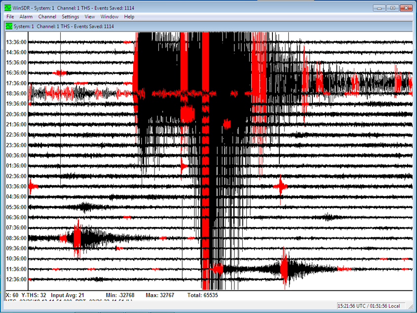
The devastating magnitude 7.5 earthquake in PNG 28th Feb 2018 recorded at THS, a site near Modbury Heights in South Australia.
2 magnitude 4 aftershocks are clearly visible on the above seismogram.
Everyone in our 'network' recorded the last North Korean nuclear blast on their instruments.
We also deploy portable seismic recording instruments in temporary installations in regions where seismic activity occurs.
All of our data goes into the Australian seismic data bases and is available at no cost to researchers and other interested people world wide.
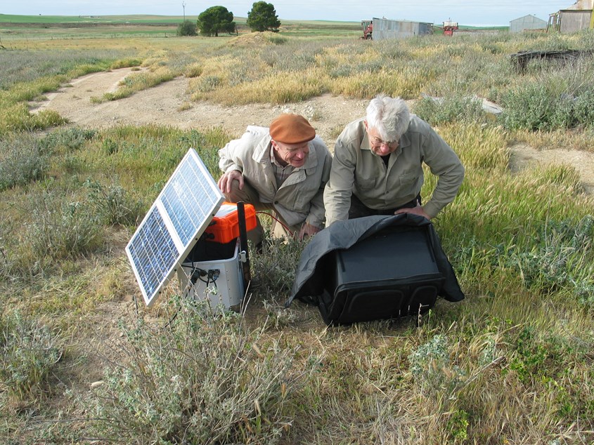
SAA's Chief Seismologist David Love and Chairman Blair Lade deploying a portable solar powered instrument at Yongala SA during a seismic 'swarm' in September 2011. About 200 seismic events were recorded and analysed to produce 'focal mechanisms' from this swarm. One of the locals we spoke to during the deployment said she could feel the larger events and could hear lots more.
Data recorded by our instruments is automatically sent via the internet to
- Melbourne University has a server (Melbourne EQserver) where the data is stored.
- Data from our PSN sites are also sent to a server in Western Australia at the Australian Centre for Geomechanics.
- Some of our stations are beginning to use Raspberry Shakes and the data is sent to the OSOP data repository as well as to our servers in Australia. Read the review by the ANU about the suitability of Raspberry Shakes in a network such as ours under 'Downloads'.
Latest interesting earthquakes in and near Australia
Angaston 21st October 2021
A small earthquake occurred at 5:34 (local Adelaide time) this afternoon (Thu 21st Oct).
The epicentre was 9km east of Angaston, and it had a depth of about 8km.
It had a magnitude of about 2.2.
It has been weakly felt by some people across the Barossa Valley.
This earthquake is considerably smaller than the magnitude 4.8 event near Pinnaroo on 9th October (see below), and the aftershocks magnitude 3.1 and 2.9 that happened in the last 2 days, and is not related to these events.
While the Mount Lofty Ranges are not particularly active, the eastern edge of the ranges does have occasional earthquakes. Usually they are single events, with no following activity.
The location and depth of this afternoon’s shock is fairly accurate due to the large number of recorders operated the Seismological Association of Australia in the region. There are a few more operated by Geoscience Australia and the Australian National University.
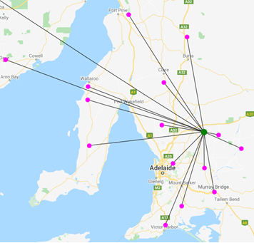
Angaston event 21/10/2021, pink dots are the locations of the recorders used to locate the event (green dot).
David.
Murrayville / Pinnaroo earthquake 9th October 2021
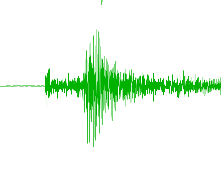
In the early hours on Saturday morning, a M4.8 earthquake occurred on the SA Vic border near the town of Pinnaroo. Estimated depth is 2km. This event was well recorded by instruments across Victoria and South Australia. Here's a screen shot from site THS near Adelaide.

As you can see in the above seismogram, there were a few aftershocks, so SAA's Chief Seismologist David Love and Chairman Blair Lade, decided to deploy some portable aftershock recorders. A quick testing session and a 3 hour drive saw us at Pinneroo just after 1pm. We spoke with the local Policeman (Matt) who suggested we make contact with local farmer (Wade) who lives about 10km from the preliminary event location and on the SA side of the border.
(due to current Covid restrictions, we're not allowed to cross the border into Victoria without spending time in quarantine on returning to South Australia).
Wade (the farmer) was most accommodating and together, Wade, David and I installed 3 portable recorders along the border. Later that night, there were a couple of aftershocks including a M2.7. We spoke with a few locals who all felt 'severe shaking', with the town's dogs going absolutely 'bananas'!
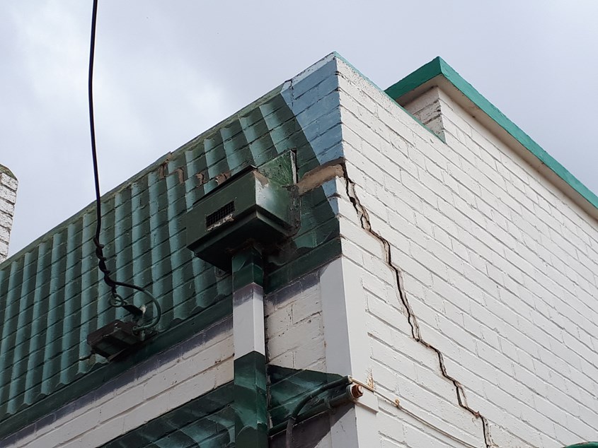
I spotted this rather fresh looking crack in the front wall of the local Community Centre, It's following a much older repaired crack. The top of the wall has moved several cm.
We'll recover the portable recorders in a week or so once it appears that there are no more aftershocks.
update..
There were 2 larger aftershocks at this location on the 19th and 20th, so we're going to leave our aftershock recorders out for another week.
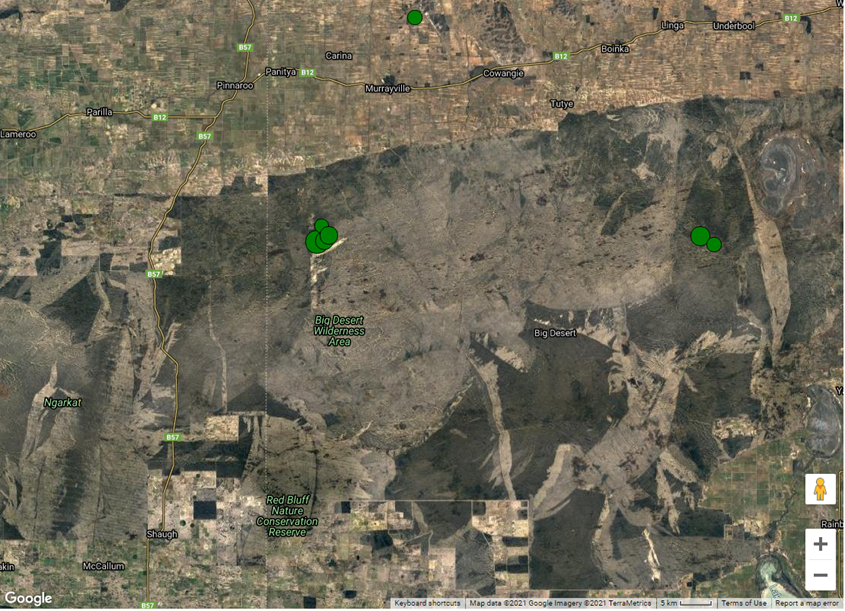
Satellite image showing the location of the 4 main events at Murrayville October 2021, M4.7, M3.1, M2.9 and M1.8
The 2 events on the RHS are from January 2018 M3.5 and M2.1
The event at the top of the image was from May 2018 M2.1
Blair
Mansfield / Fiddlers Fault (Wood's Point) Earthquake in Victoria 21st September 2021
Click on the link above to download a pdf
VAY station is part of the centralized Macedonian seismic network run by the Seismological Observatory in Skopje
Mansfield Earthquake, 22 Sep 2021, Magnitude 5.8
David Love
Chief Seismologist, Seismological Association of Australia Inc.
It has been well recorded by seismographs across the country, including many private seismographs in houses and backyards. Recordings at Brighton and Payneham in South Australia show peak movement of 2 to 3 mm/s at low frequencies. This is below the felt thresh-hold, however there is usually amplification in multistory buildings, resulting in this event being felt by a large number of people around Adelaide.
The earthquake has been widely felt at ground level across of much of Victoria, and into southern New South Wales.
This is the largest earthquake in onshore Australia since a magnitude 6.1 event in the south-west of the Northern Territory. The 2016 Petermann Ranges (north of Ayres Rock in the Northern Territory) earthquake caused a large crack in the ground for a length of about 20 km.
The depth of today's earthquake is not known, so is usually listed at the default value of 10 km. This is because the nearest seismographs are so far away. If it is shallow (say 5 km) it may have caused a crack that can be measured. If it is deep (say 20 km) there is unlikely to be anything to see at ground level. It has probably caused a rupture of 50 to 100 square kilometers.
There have been numerous aftershocks already. Seismologists are planning to get extra instruments out to the epicentral area in the next day or two. If the earthquake is deep it is likely that aftershocks will die away within days, but if it is shallow, they may persist for months.
Aftershocks from a 2016 magnitude 5.8 earthquake offshore from Bowen have continued for 5 years, and aftershocks from the 1988 Tennant Creek earthquakes are still going over 30 years later.
High-rise buildings in Adelaide are occasionally shaken by earthquakes. Some of the most extreme reports have been following large deep earthquakes in Indonesia, in 1963 and 1978. There is almost no monitoring in buildings in the whole of Australia unfortunately.
David
Locations of recent Earthquakes Determinations by SAA of Australian seismic events (requires FireFox or Google Chrome)
GeoScience Australia Zoomable map showing recent activity by the Australia Government Agency responsible for monitoring earthquakes in and near to Australia
PSN stations. Unfortunately, the site (CQSRG) where we sent our PSN images has closed. Screen shots from our PSN sites are no longer available.
IRIS Seismic Monitor World wide activity monitor for events greater than Magnitude 4
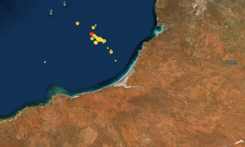
Seismic activity off the Western Australia coast in July 2019, image from GeoScience Australia
Downloads
'Flyer' about the Seismological Association of Australia 2021
Membership Application form 2021
ANU review of Raspberry Shakes 2018
For students
Newsletters of the SAA
All the newsletters of the Seismic Association of Australia are available from our new web site.
Seismic Links
Please go to our new web site, we have more seismic related links there.
Seismology Research Centre (SRC) an Australian site with free software and information, part of ES&S
GeoScience Australia the Australia Government Agency responsible for monitoring events across Australia
Australian National University, Research School of Earth Sciences (Seismology)
IRIS Seismic Monitor World wide activity monitor for events greater than Magnitude 4
https://seiscode.iris.washington.edu/projects Link to various projects, resources and software at IRIS
Australian Centre for Geomechanics in Perth
Flinders Ranges Earthquake Hypocentres, Download the 10Mb file, save it to your PC, open it, enable 3D, click 'Transparent' on DTM and have a look around!
Amateur seismology in Australia , 'a review' by Vic Dent
GEO, The Independent Organisation for Weather Satellite and Earth Observation Enthusiasts
Earthquake_clusters_in_the_southwest_Australia_seismic_zone_June_2016_-_May_2017
Alan Jones is a US researcher who has written a lot of earthquake related software, Amaseis, Seismic Eruptions, Seismic Waves, Eq Locate, Jamaseis (monitor stations around the world on your PC 'Live')
Current Seismicity from instruments in Australia Melbourne EQserver (latest hour)
Melbourne EQserver where you can 'look around the network', search past dates and events.
A really good link about charging batteries, I've put this in because we use a LOT of batteries throughout our network.
Want to run your own seismic station? Then have a look at Raspberry Shakes, a seismic recording system based around the Raspberry Pi with an add on board. Data from 'Shakes' is automatically sent to a world wide repository which is available to researchers. You can also send your data to us!
Seismological Association of Australia contact details
Chairman and website content, Blair Lade, blair.lade@gmail.com
Treasurer / Secretary, Joe Grida, joe.grida@internode.on.net
Please put 'Seismic Association' in the subject header as we both get a lot of emails.